Innovative student redraws District boundaries
Freshman Patrick Evans, frustrated with the seemingly inadequate boundary adjustments, re-drew the boundary map, taking into account population and placement of middle and elementary schools.
The Beaverton School District started its boundary readjustment process recently, and when the spring-board model was released, it’s making light of the matter to say that people were angry.
“It could have been done so much better,” said senior Cole Cavanaugh. “It seems like they didn’t account for anything other than population.”
Based on the first boundary model, Cavanaugh’s comment seems true. Though population problems are fixed, most schools struggling with poor distribution of wealth aren’t properly addressed.
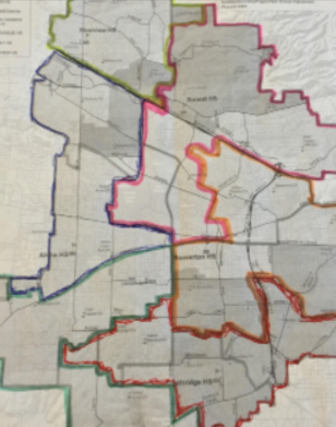
With a sketched-out, redrawn map of the high school boundaries, Beaverton freshman Patrick Evans is hoping to make a difference.
“I found out about the new district boundaries they’re planning to send out,” said Evans, “and it takes away so much of Beaverton’s territory. Almost 75% of it is lost, and it just split up so many communities…We needed to redraw the maps so that it fits more of the District’s promotion of equity.”
Evans took many factors into account when he redrew the map, including elementary schools, communities, and sports teams. His goal was to cap each high school at three feeder middle schools without boundaries extending too far away.
“The schools have built this community, like Beaverton has over the past 100 years, so it’s important that the parents and students don’t lose that connection they have with the communities,” Evans said. “And that you don’t break up that many families from what they’ve been with for so long. You can get like four generations of Beaverton families sometimes, and then you’re just forcing them to go to Southridge.”
Evans also considered poverty levels within each high school. “In my model, I addressed Aloha’s poverty by moving some of their borders to the north, McKinley and Elmonica elementary schools are both former Westview schools and are a lot lower in poverty than some of the current Aloha schools. And so moving some of those Aloha schools to South Cooper Mountain to balance them out works as well.”
This creates equality within the district more so than the proposed redrawing, where Aloha and Beaverton take a large hit within poverty levels.
“With the district’s boundaries, Beaverton would be above half of the students needing free and reduced lunch,” Evans said, “but Southridge would move up to half. Sunset would go down to below 20% and Westview and South Cooper Mountain would be around 25%.”
Beyond alleviating overcrowding in schools, the boundaries are an opportunity for the District to meet its goals regarding equity. And improvements to the current plan, such as Evans’, can be made to ease the transition for students and communities involved in each school’s culture, tradition, and foundation.
“The district can do more as far as making the schools equitable,” said Evans.
Your donation will support the student journalists of Beaverton High School. Your contribution will allow us to cover our annual website hosting costs and bring more news to you!